

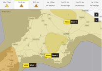
Parts of Dartmoor could see snowfall tomorrow with forecasters warning that there may be disruption and difficult travelling conditions through Thursday evening (January 8) and into Friday morning (January 9).
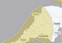
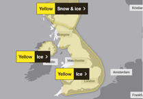
The Met Office has issued a yellow snow warning covering higher ground in Devon, including Dartmoor, Chudleigh, the A38 Haldon Hill and A380 Telegraph Hill from 8pm on Thursday until 9am on Friday.
An additional yellow weather warning for wind covers the whole of the South West between 3pm on Thursday until 6am on Friday.
The snow, strong winds and heavy rain are due to a deep area of low pressure, which has been named Storm Goretti by Météo-France because the strongest winds are most likely over Northern France.

“Storm Goretti will be a multi-hazard event,” commented Met Office chief forecaster Neil Armstrong. “A period of strong winds is likely across southwestern areas on Thursday afternoon and evening, with gusts of 50-60 miles per hour (mph) possible fairly widely, and 60-70mph along exposed hills and coasts.”
There is some uncertainty over the exact track of Storm Goretti, which will influence the locations most likely to see disruptive snow. Amounts of snow will also depend quite heavily on both elevation and the intensity of precipitation, and as this becomes somewhat lighter into Friday this will lead to an awkward mix of rain, sleet and snow, gradually clearing away to the east. Therefore there is likely to be a lot of variation, even over relatively short distances.
The UK Health Security Agency (UKHSA) currently has an amber cold weather health alert in place across England until January 11.
Snowy, wintry weather can cause delays and make driving conditions dangerous and drivers are being advised to consider whether it is safe to get behind the wheel as weather conditions worsen.
Those who do choose to drive should: plan their route and check for delays and road closures; leave more time to prepare and perform safety checks on the car before setting off; and ensure essentials are packed in the car in the event of any delays, such as warm clothing, food, water, a blanket, a torch, ice scraper/de-icer, a warning triangle, high visibility vest and an in-car phone charger.
“As temperatures plummet, breakdowns rise, especially as older, less reliable batteries tend to fail more in cold conditions,” commented RAC breakdown spokesperson Alice Simpson. “The key is allowing more time at every stage of the journey, whether that's clearing vehicles of snow and ice before setting off or reducing the speed at which you’re travelling to suit the conditions,” she added.
While the Met Office expects ‘a short-lived interlude of calmer weather for many on Saturday’, it has warned that the forecast is more uncertain for Sunday and beyond.
‘It will remain cold to start the weekend, although for most it will be dry. We then have very large uncertainties in the forecast by Sunday and Monday as milder air from the Atlantic tries to displace the cold air over the UK,’ commented Met Office deputy chief forecaster Mark Sidaway. ‘This set up brings a risk of some further widespread snowfall, so it is important to stay aware of the forecast and any warnings which may be issued over the next few days.’
Comments
This article has no comments yet. Be the first to leave a comment.